Amusement park in San Fernando de Henares
Competition. 3rd Prize
2024
Architects: Ignacio Borrego, Carlos Chacón, and José de Villar
Collaborators: Gonzalo Álvez. Brandt, Sabrina Danese, Pablo Mtínez. Collar, and Marina Morgan
Illustration: Alejandro de Miguel
Visualizations: Three-visual
Location: Finca “El Batán”, San Fernando de Henares
Client: San Fernando de Henares City Council
Area: 61,485 m2
Francisco de Goya’s painting “The Meadow of San Isidro” depicts a panoramic view of Madrid from the banks of the Manzanares River, capturing the festivities of San Isidro Day, the city’s patron saint. The scene shows a crowd enjoying the countryside, with the city in the background.
This painting is significant for us for two reasons. First, for its focus on urban society in relation to nature within a festive scene that captures the essence of Madrid and its popular culture of the time, integrating the urban and natural landscape. Secondly, its approach to a topographical reality, with two levels in an artificial riverside landscape, suggests we harness its potential.
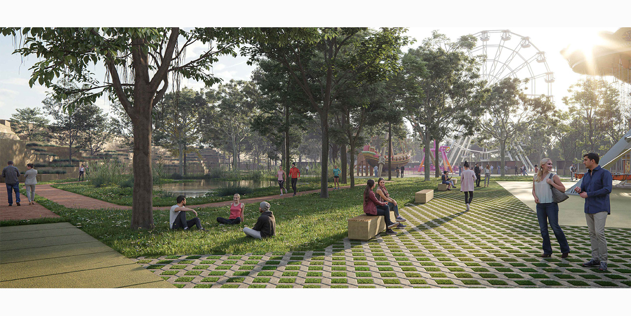
Our objective is to transform the “El Batán” estate into a multifunctional space that articulates the urban and the natural, both for festive events and for the daily use of citizens within the 21st-century riverine environment of the Jarama riverbank.
The project for the amusement park on the banks of the Jarama proposes an operation based on four ideas:
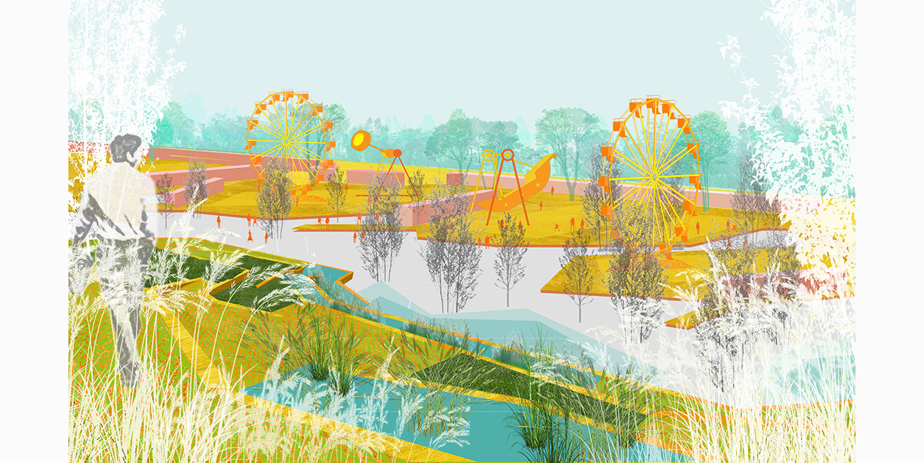
01 BUILDING A THRESHOLD TO THE NATURAL LANDSCAPE OF THE JARAMA
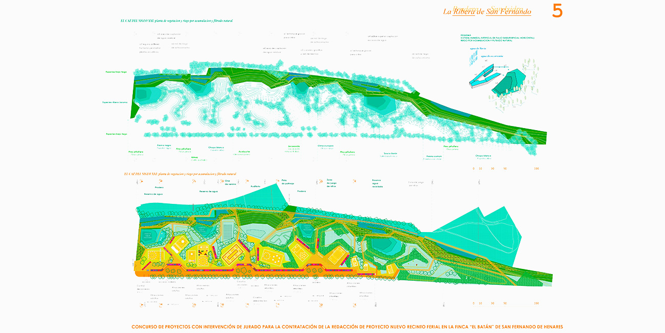
The heart of the proposal constructs a hydraulic and topographical system that extends the biodiversity of the natural ecosystem of the Jarama riverbank through water features. These irrigated or flooded areas facilitate the emergence and maintenance of endemic species such as rushes and water lilies, and deciduous trees such as poplars, ash, elms, willows, and aspens, and evergreens such as stone pines and wild olive trees.
The vegetation, shade, and water will favor the fauna associated with the river, with birds such as ducks, herons, cormorants, and wagtails, or fish such as barbel, carp, and trout, or river amphibians.
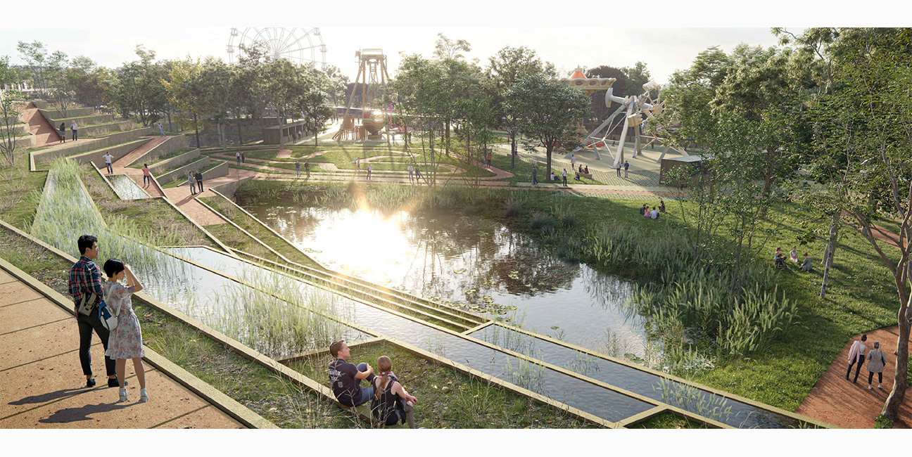
02 WATER MANAGEMENT AS A DRIVING FORCE FOR NATURE
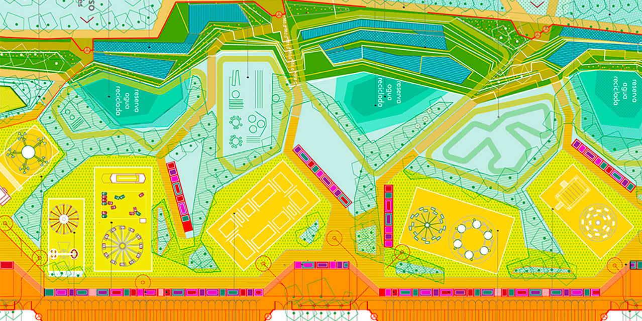
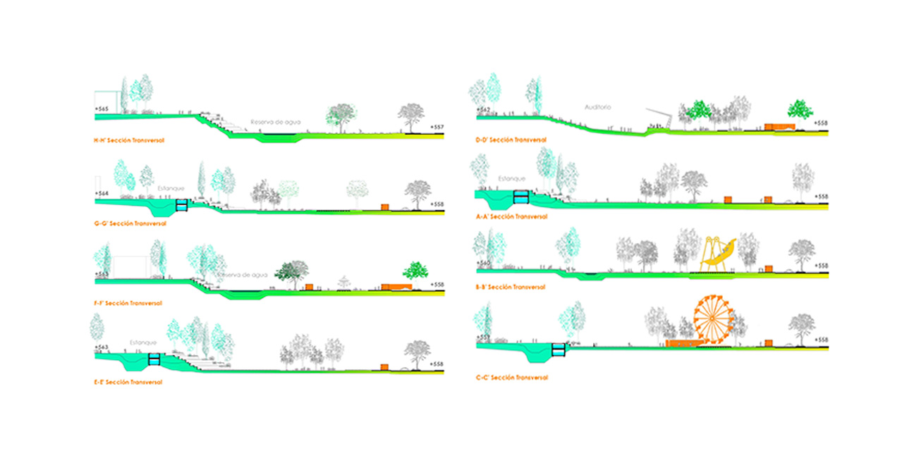
Filtering, purifying, and storing. The project seeks a balance between natural growth and the arboricultural approach through water management and soil planning. Two types of collectors are proposed: one for treating stormwater runoff from the city on the slope to the west of the site, and a second for drainage and water control at the lower level of the park and fairgrounds.
Within the slope, underground water storage tanks and surface water features with vegetation and stone and gravel filters are constructed, creating a purification, storage, and irrigation system alongside the original irrigation channel, reflecting the spirit of this protected cultural heritage site.
At the park level, the natural water flow is reconstructed, fed by water filtered from the slope and collected through drainage systems in the surrounding soil. Excess water is directed to clean water tanks, also located on the slope.
It is proposed to define areas of minimal landscaping intervention in the lower areas and on the slopes, where the water supply alone will generate native, spontaneous vegetation. Conversely, other more controlled areas with different maintenance are defined to facilitate the growth of species that provide shade and have low water requirements.
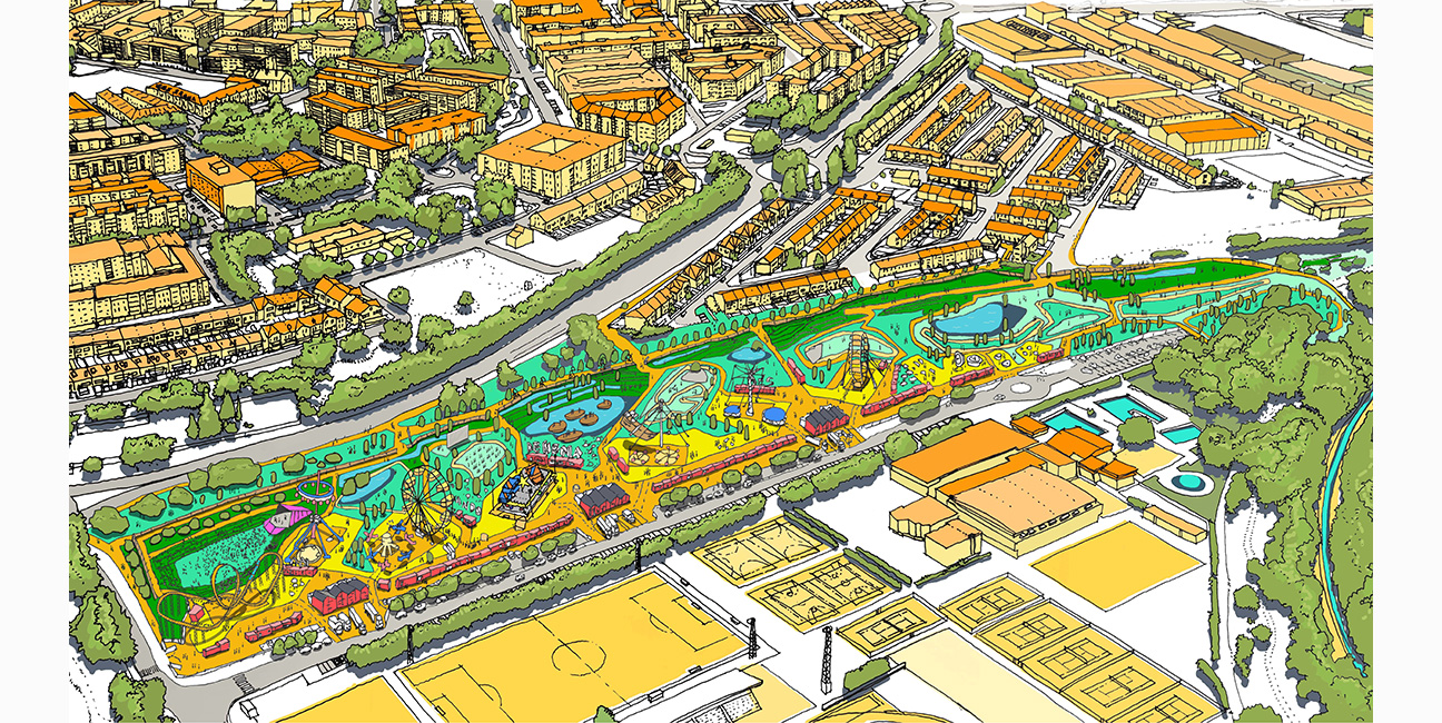
03 INTEGRATING THE URBAN WITH THE NATURAL
The soils are categorized into seven types with varying gradients from natural to urban. The fairgrounds, which alternate with sports facilities, are located on the eastern edge, adjacent to the existing sports facilities. For this purpose, high-resistance platforms with installations are planned (1), bordered by semi-perforated walkable platforms (2). Beyond these, and transitioning towards the natural environment, there are pathways with permeable paving (3), surface water accumulation areas (4), water filtration areas (5), areas for permanent planting (6), and areas for seasonal spontaneous vegetation (7). This transition culminates in the slopes on the western edge, which bridge the sharp difference in elevation with the adjacent urban area. The existing irrigation channel runs beneath these slopes, and rainwater collection tanks are planned on two levels. These tanks will operate by gravity to filter, purify, and irrigate the green areas.
Each of these areas allows for different uses that will be flexible throughout the seasons.
04 ACCESSIBILITY AND INTEGRATION WITH THE EXISTING ENVIRONMENT
The boundaries of the future fairgrounds need to resolve the break caused by the discontinuity between the urban core levels and the general site level, also facilitating future pedestrian access from the urban core without having to go around the park and creating a more natural connection with the sports area.